ArcGIS in Mapit
General information
As of version 2.1 Mapit enables integration with ArcGIS, which makes it possible to:
- Display ArcGIS layers on the map
- Issue creation for the selected ArcGIS object
- Search ArcGIS objects
Configuration
To add ArcGIS layers in Mapit, go to the Map settings section in the JIRA admin panel and then, below, find the Map sources block and the Add new ArcGIS source button.

After pressing the Add new ArcGIS source button, the following line will appear in the table with the data sources.

Enter the name that will be displayed in the user's Mapit menu and enter the URL for ArcGIS source and select the checkbox in the Show column. The entered data is saved automatically.
Currently supported ArcGIS sources in Mapit are:
- MapServer
- FeatureServer
If the ArcGIS server is not an open data service, you need to provide access credentials.
Press the Details button to open the dialog box.

In the dialog box, enter the data:
- Username: Username for ArcGIS Server
- Password: Password for ArcGIS Server
- Generate Token Url:
- Ask the ArcGIS administrator for this url.
- It usually looks like this: https://___ARCGIS_SERVER_URL__/arcgis/tokens/generateToken
- Find out more about Generate Token Url
- More information can be found here.
For open data access, the above settings are not required.
For better performance, it is possible to optionally set:
- Furthest zoom level the layer will be displayed on the map: A number indicating the furtherst zoom level in witch ArcGIS elements will show on the map.
- Closest zoom level the layer will be displayed on the map: A number indicating the closest zoom level in witch ArcGIS elements will show on the map.
Integration with ArcGIS
You can use information from ArcGIS objects in your Jira issues.
In order to integrate the ArCGIS data source with JIRA, mapping must be performed.
Mapping Customfields with ArcGIS fields means that when creating an issue from the Mapit component, ArcGIS data will be copied to customfields.
- To map fields, press the button Add new mapping
- then select the JIRA project key, customfield field, and ArcGIS field
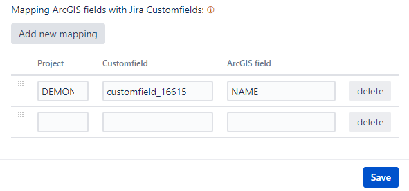
- It is possible to edit and delete existing mappings
- If an ArcGIS server with open data is used, or the connection details are correct, the administrator will be able to select ArcGIS fields from the list
Furthest and closest zoom levels
Setting zoom level for ArcGIS information is optional, but you might want to set this limitation to improve the user experience and avoid performance issues.
If you don't set anything in this setting, ArcGIS information will be loaded when ever a user selects a dataset from Mapit menu.
Setting a zoom level ArcGIS information will only load and show on the map when the zoom level is within furthers and closest levels indicated in this setting.
So for instance:
Without any limits set, if a user selects one or more ArcGIS dataset, and zoom out on the map, more and more data will be retrieved (assuming the data set covers the geographical area shown) If you are useing a nation wide ArcGIS service and showing the entire country on the map, this might potentially be a lot of data. The map would probably be covered in indicator-dots making it difficult for the user to locate the information they were looking for.
Setting the zoom level to the levels of say street level to metropolitan area, a user can zoom to wide metropolitan area and navigate on the map without having to wait for ArcGIS data. And then zoom to se more details including the ArcGIS data provided.
What numbers to use for zoom level will depend on the map source you are using.
A practical example
Here is an example of an open data set that you can try out.
Enjoy!